
NEWS:

The mission of the WRIA 35 Planning Unit is to treat water as a valuable resource through the development and implementation of a watershed plan consistent with RCW 90.82 for the beneficial management of water resources to balance the present and future needs of local rural and urban communities, agriculture and other industries, fish and wildlife, and tribal communities and treaty rights.
Learn more about the Middle Snake Watershed and how citizens, local, state, and federal governments, tribes, and others have joined together to enhance the health of water resources and to ensure water supply reliability into the future.
Lead Agency: Asotin County Public Utility District
Watershed planning information or to get involved:
Website Feedback:
Adapted from the 2002 Snake River Limiting Factors Report (Washington Conservation Commission)
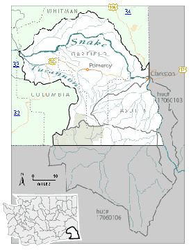
The Middle Snake Watershed (WRIA 35) is located in the extreme southeast corner of Washington. The WRIA is bordered by the state of Oregon to the south, the state of Idaho to the east, the Palouse Watershed (WRIA 34) to the north, and the Walla Walla (WRIA 32) and Lower Snake (WRIA 33) Watersheds to the west. The basin drains approximately 2,250 square miles within the state of Washington. (NOTE – Approx. 340 square miles of the lower Grande Ronde Watershed is located within WRIA 35 boundaries but is not part of the planning effort). The Middle Snake Watershed encompasses portions of Asotin, Whitman, Garfield, and Columbia Counties within Washington. Diamond Peak, located in the headwaters of the Tucannon River, is the highest point in the basin with an elevation of 6,380 feet, while the confluence of the Snake and Tucannon Rivers is the lowest point at approximately 540 feet.
The Middle Snake Watershed is semi-arid. Average annual precipitation ranges from 5-10 inches in the lowlands along the Snake River up to 45 inches in the peaks of the Blue Mountains.
Primary surface water bodies include the Snake River, Tucannon River, Asotin Creek, and Pataha Creek. Little Goose Dam (RM70) and Lower Granite Dam (RM107) impound the Snake River in WRIA 35. The backwater from Lower Granite Dam extends upstream to the City of Asotin (RM146). The Snake River is free-flowing from this point up to Hells Canyon Dam (RM247) located upstream from the upper end of WRIA 35. Groundwater flows through cracks in the basalt layers as well as the porous sediments sandwiched between the basalts, carrying considerable quantities of groundwater that supply water for irrigation and municipal uses.
Historically, the Middle Snake Watershed was covered with prairie and canyon grasslands and shrub-steppe vegetation. Today, much of the land area in the WRIA (43%) has been converted to crop and livestock production. Non-irrigated row crops, primarily wheat, and grass-forb plant communities comprise roughly 37% and 30% of vegetative cover in the watershed respectively. Coniferous forests cover approx. 20%, while a mixture of shrubs and trees covers 7%.
The total population of Asotin County in 2000 was 20,551, 19,256 of which lived in the cities of Asotin or Clarkston and surrounding areas. No major population centers are present in the Whitman County portion of the WRIA. The city of Pomeroy was the most populated area in Garfield County with 1,517 residents. The largest town in the Columbia County portion of the WRIA was Starbuck with a population of 130 in year 2000. Private land comprises 1,711 square miles (76%) of the WRIA, while the federal government manages 436 square miles (19%), and the state of Washington manages 103 square miles (~5%).
In June of 2011, the WRIA 35-Middle Snake Watershed Planning Unit adopted an updated Detailed Implementation Plan and completing Phase 4 of the Watershed Planning Process. Having gained 100% consensus on Instream Flows, the Planning Unit was positioned to move forward with rule setting on identified streams.
Unfortunately due to budget cuts at Ecology the WRIA 35 Planning Unit was deemed a non-priority due to limited funding. Ecology has focused their Instream Flow Rule Setting process on those areas where there is a higher population base and with challenging water issues. The Planning Unit anticipates that in 2 to 4 year the Instream flow rule making process will begin.
The Planning Unit continues to be staffed with a Watershed Planning Director thanks to funding from the Snake River Salmon Recovery Board, Department of Ecology and other contractor’s and agencies. The Planning Unit will continue to seek funding for projects identified in the updated Detailed Implementation Plan and meetings of the Planning Unit members will occur as needed.
Planning Unit Administrative Documents:
With the passage of the Watershed Management Act of 1998, Washington State established a pathway for developing locally-based watershed enhancement plans based on Water Resource Inventory Areas, or WRIAs. This optional program is outlined in Chapter 90.82 RCW and provides a framework within which citizens, tribes, local governments and others can collaborate to develop watershed management plans. Sponsored by the Washington Department of Ecology, all watershed management plans address water supply reliability issues, while water quality, instream flows, and habitat are optional.
In the Middle Snake Watershed (WRIA 35), Asotin, Columbia, Garfield, and Whitman Counties, the City of Clarkston, and the Asotin County Public Utility District joined to initiate organization of the WRIA 35 Planning Unit in 2002. The 37-member Middle Snake Watershed Planning Unit is comprised of the initiating governments and the following stakeholder groups:
The watershed planning process in WRIA 35 will address water supply, instream flows, water quality, and habitat issues. In summer, 2003, development of the Level 1 Technical Assessment will begin. This assessment will summarize current conditions in the watershed, and will identify existing data gaps. Completion of the Level 1 Assessment is anticipated by June, 2004. The Level 2 Technical Assessment will follow, focusing on detailed studies and gathering additional information to fill in those data gaps. These technical assessments will feed into the watershed management plan, tentatively scheduled for completion by the end of 2006. This watershed planning process will be coordinated with Salmon Recovery Planning and BPA Subbasin Planning ongoing in the watershed.
DETAILED IMPLEMENTATION PLAN
HYDROGEOLOGY
Final
Phase 1
INSTREAM HABITAT ASSESSMENT
TUCANNON AND PATAHA TMDL STUDY
ADOPTED WATERSHED PLAN (posted August 31, 2007)
SECTIONS
APPENDICES
OTHER PLANNING DOCUMENTS
HABITAT PROJECT REPORTS
FINAL LEVEL 1 ASSESSMENT DOCUMENTS
MULTI-PURPOSE STORAGE ASSESSMENT
WATER QUALITY ASSESSMENT
INSTREAM FLOW ASSESSMENT
GRAND RONDE ASSESSMENT
WATER STORAGE
WATERSHED PLAN
Copyright © 2020 Asotin PUD | Website designed by Advantage Advertising, Inc.
Our office will be closed for a computer system upgrade beginning at 11:00 am on Friday July 10th.
All Payment Systems will be unavailable July 10 – 11.